Geography
Purpose of study
A high-quality geography education should inspire in pupils a curiosity and fascination about the world and its people that will remain with them for the rest of their lives. Teaching should equip pupils with knowledge about diverse places, people, resources and natural and human environments, together with a deep understanding of the Earth’s key physical and human processes. As pupils progress, their growing knowledge about the world should help them to deepen their understanding of the interaction between physical and human processes, and of the formation and use of landscapes and environments. Geographical knowledge, understanding and skills provide the frameworks and approaches that explain how the Earth’s features at different scales are shaped, interconnected and change over time.
At Langley one of the threads running through our curriculum provision is 'To know how we can make an impact and take responsibility'. We ensure our children have a good understanding of global issues. We are currently working on updating our 'Eco School Green Flag Award'.
We use key enquiry questions in our learning.
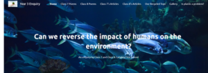
Our Year 3 website created by the children to answer the key question - Can we reverse the impact of humans on the environment? They have helped complete a beach clean in our local area to reduce plastic pollution. Find out more here

Aims
- develop contextual knowledge of the location of globally significant places – both terrestrial and marine – including their defining physical and human characteristics and how these provide a geographical context for understanding the actions of processes
- understand the processes that give rise to key physical and human geographical features of the world, how these are interdependent and how they bring about
spatial variation and change over time - are competent in the geographical skills needed to:
- collect, analyse and communicate with a range of data gathered through experiences of fieldwork that deepen their understanding of geographical processes
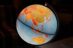
- interpret a range of sources of geographical information, including maps, diagrams, globes, aerial photographs and Geographical Information Systems (GIS)
- communicate geographical information in a variety of ways, including through maps, numerical and quantitative skills and writing at length.
| EYFS | Y1 | Y2 | Y3 | Y4 | |
|---|---|---|---|---|---|
| Locational Knowledge NC KS1 Develop contextual knowledge of the location of globally significant places. NC KS2 Understand geographical similarities and differences through studying the human and physical geography of a small area of the United Kingdom, and of a small area in a contrasting non-European country. | Describe their immediate environment using knowledge from observation, discussion, stories, non-fiction texts and maps. (ELG) Know some similarities and differences between the natural world around them and contrasting environments, drawing on their experiences and what has been read in class. (ELG) | To name some of the main towns and cities in the United Kingdom. To name a few towns in the south and north of the UK. To use locational and directional language e.g. near and far: left and right) to describe the location of features and routes. | To use simple compass directions (N,E,S,W) and locational and directional language e.g. near and far; left and right to describe location of features and routes on a map. To name and locate the world’s seven continents and five oceans. To name, locate and identify characteristics of the four countries and capital cities of the United Kingdom. To name the main cities of England, Wales, Scotland and Ireland. To find where they live on a map of the UK. To name, locate and identify characteristics of the seas surrounding the United Kingdom. | To name the two largest seas around Europe. To identify where countries are within the UK and key topographical features. To name and locate largest cities of the UK. To name and located the capital cities of neighbouring European countries. | To recognise the different shapes of continents. To identify where countries are within Europe; including Russia. To know how the locality is set within a wider geographical context. To name and locate counties of the UK. To locate and name some main islands that surround the UK. To list six cities in the UK and locate them on a map. To know about the wider context of places e.g. regions and countries. To know the difference between the British Isles, Great Britain and UK. |
| Place KnowledgeNC KS1 Understand geographical similarities and differences through studying the human and physical geography of a small area of the United Kingdom, and of a small area in a contrasting non-European country. NC KS2 Understand geographical similarities and differences through the study of human and physical geography of a region of the United Kingdom, a region in a European country, and a region within North or South America. | Explore the natural world around them, making observations and drawing pictures of animals and plants. (ELG) | To explain the main features of a hot and cold place. To describe seasonal weather changes. To explain what they might wear if they lived in a very hot or a very cold country. | Identify the location of hot and cold areas of the world in relation to the Equator and the North and South Poles. To make plausible predictions about what the weather may be like in different parts of the world. To explain what facilities a town or village might need. | To recognise there are similarities and differences between places. To develop an awareness of how places relate to each other. | To recognise that people have differing quality of life living in different locations and environments. To explain why people may choose to live in a village rather than a city. To describe human features of UK regions, cities and/or counties To explain why people are attracted to different cities. To explain about key natural resources e.g. water in the locality. To understand why there are similarities and differences between places. |
| Human and Physical Geography NC KS1 To identify seasonal and daily weather patterns in the United Kingdom and the location of hot and cold areas of the world in relation to the Equator and the North and South Poles. To use basic geographical vocabulary to refer to human and physical features. NC KS2 To describe and understand key aspects of: Physical geography, including: climate zones, biomes and vegetation belts, rivers, mountains, volcanoes and earthquakes, and the water cycle. Human geography including: types of settlement and land use, economic activity including trade links, and the distribution of natural resources including energy, food, minerals and water | Know some similarities and differences between different religious and cultural communities in this country, drawing on their experiences and what has been read in class. (ELG) Explain some similarities and differences between life in this country and life in other countries, drawing on knowledge from stories, nonfiction texts and – when appropriate – maps. (ELG) | To understand how some places are linked to other places e.g. roads, trains. To name key features associated with a town or village, e.g. factory, detached house, semi-detached house, terrace house. To link own homes with other places in the same local community. | To consider how people often ‘spoil’ the area or make it better. To describe some of the features associated with an island. To identify seasonal and daily weather patterns in the UK. To say what they like and don’t like about own locality and another locality like the seaside. To understand geographical similarities and differences through studying the human and physical geography of a small area of the UK and of a small area in a contrasting non- European country. To explain how the jobs people do may be different in different parts of the world. | To explain how people's lives vary due to weather. To describe how volcanoes are created. To describe how earth quakes are created. To identify physical and human features of the locality. To explain why a locality has a certain physical features. To explain about weather conditions/patterns around the UK and parts of Europe. | To demonstrate knowledge of features about places around him/her and beyond the UK. To name areas of origin of the main ethnic groups in the UK and in own school. To understand the effect of landscape features on the development of a locality. To describe how people have been affected by changes in the environment. To explain how a locality has changed over time with reference to physical features. To explore weather patterns around parts of the world. |
| Geographical skills and fieldwork NC Aims [Children] are competent in the geographical skills needed to: collect, analyse and communicate with a range of data gathered through experiences of fieldwork that deepen their understanding of geographical processes and interpret a range of sources of geographical information, including maps, diagrams, globes, aerial photographs and Geographical Information Systems (GIS).Children also need to be able to communicate geographical information in a variety of ways, including through maps, numerical and quantitative skills and writing at length. | Use and understand recently introduced vocabulary during discussions about stories, non-fiction, rhymes and poems and during role-play. (ELG) | To ask simple geographical questions e.g. what is it like to live in this place. To use simple observational skills to study the geography of the school and its grounds. To use simple maps of the local area e.g. large scale, pictorial etc. To make simple maps and plans e.g. pictorial place in a story. To name, describe and compare familiar places. To know about some present changes that are happening in the local environment e.g. At school. To suggest some ideas for improving the school environment. To use simple fieldwork to study the geography of the school | To use world maps, atlases and globes to identify the United Kingdom and its counties, continents and oceans studied at this key stage. To use aerial photographs and plan perspectives to recognise landmarks and basic human and physical features; devise a simple map; and use and construct basic symbols in a key. To use simple fieldwork and observational skills to study the geography of own school and its grounds and the key human and physical features of its surrounding environment. | To ask and respond to geographical questions e.g. Describe the landscape. Why is it like that? How is it changing? What do you think about that? What do you think it might be like if…continues? To analyse evidence and draw conclusions e.g. make comparisons between locations using aerial photos/pictures e.g. population, temperatures etc. To recognise that different people hold different views about an issue and begin to understand some of the reasons why. To communicate findings in ways appropriate to the task or for the audience. To make more detailed fieldwork sketches/diagrams. To use fieldwork instruments e.g. camera, rain gauge. To use and interpret maps, globes, atlases and digital/ computer mapping to locate countries and key features. To use four figure grid references. To use 8 points of a compass. | To measure straight line distances using the appropriate scale. To explore features on OS maps using 6 figure grid references.To plan the steps and strategies for an enquiry. To carry out research to discover features of cities and villages. To accurately measure and collect information (e.g. rainfall, temperature, wind speed, noise levels etc.) |
| Application of vocabulary NC KS1 To use basic geographical vocabulary to refer to: key physical features, including: beach, cliff, coast, forest, hill, mountain, sea, ocean, river, soil, valley, vegetation, season and weather, as well as key human features, including: city, town, village, factory, farm, house, office, port, harbour and shop. NC KS2 Pupils should extend their knowledge and understanding beyond the local area to include the United Kingdom and Europe, North and South America. This will include the location and characteristics of a range of the world’s most significant human and physical features. They should develop their use of geographical knowledge, understanding and skills to enhance their locational and place knowledge. | To use basic geographical vocabulary to refer to key physical features, including: beach, cliff, coast, forest, hill, mountain, sea, ocean, river, soil, valley, vegetation, season ad weather. To describe key features of a place, using words like, beach, coast, forest, hill, mountain, ocean, and valley. To use basic geographical vocabulary to refer to key human features, including: city, town, village, factory, farm, house, office, port, harbour and shop. To describe a place outside Europe using geographical words. | To understand and use a widening range of geographical terms e.g. specific topic vocabulary-meander, floodplain, location, industry, transport, settlement, water cycle etc. To use correct geographical words to describe a place and the things that happen there. To use basic geographical vocabulary such as cliff, ocean, valley, vegetation, soil, mountain, port, harbour, factory, office. | To understand and use a widening range of geographical terms e.g. specific topic vocabulary – contour, height, valley, erosion, deposition, transportation, headland, volcanoes, earthquakes etc. |
Spiritual
Geography supports spiritual development by promoting a sense of wonder and fascination with the physical and human world. An understanding of scale is an important aspect of Geography and how small changes in climate can have far reaching consequences. Understanding that all life is linked together and create the processes that make Earth the only known inhabited planet.
Moral
Geography supports moral development by looking at a range of moral issues such how the development of cites have put pressure on wildlife. We cover moral issues of an ever increasing population and the different approaches taken by countries to tackle the problem. We explore issues of poverty and the moral dilemma of importing food and the consequences of it on global warming.
Social
Geography supports social development because social issues are common themes within geography. Children discuss issues such as global warming with an emphasis on how they can make a difference by making small changes to their lifestyles.
Cultural
Geography supports cultural development by helping children to understanding different cultures. Through geography children look at how different cultures and beliefs can impact on the environment and human issues. Children look at different countries and are introduced to their customs and traditions allowing pupils to develop their humility and an understanding of the world as a global community.